Climate Letter #1692

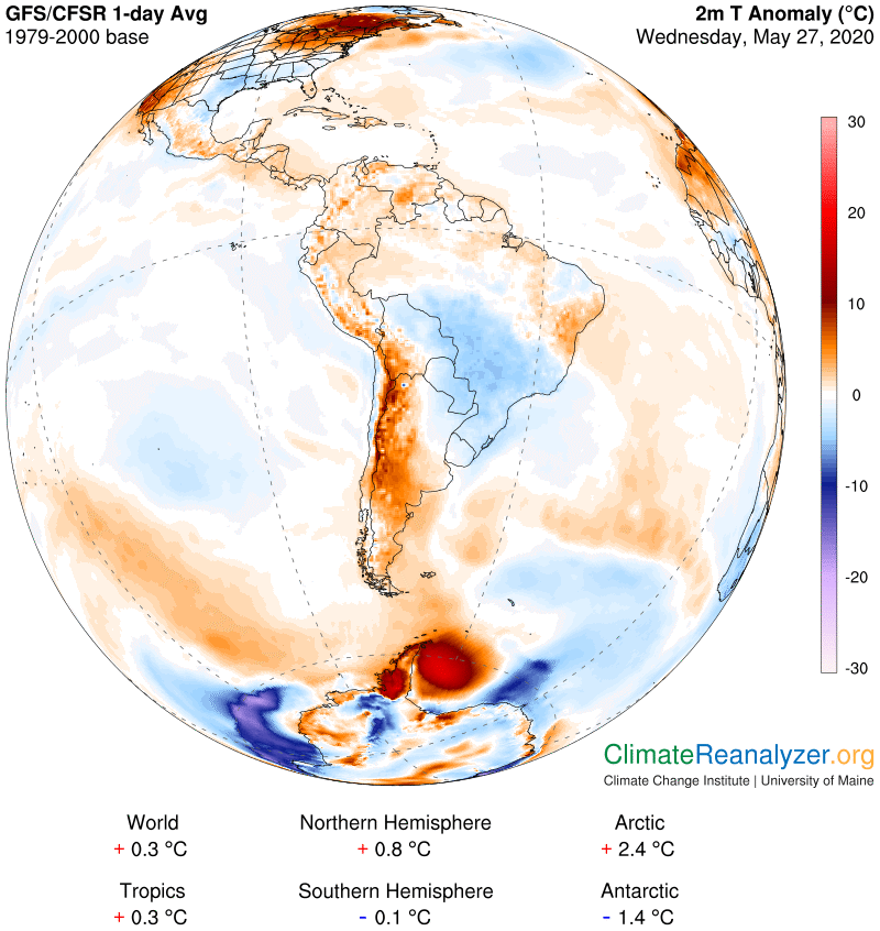
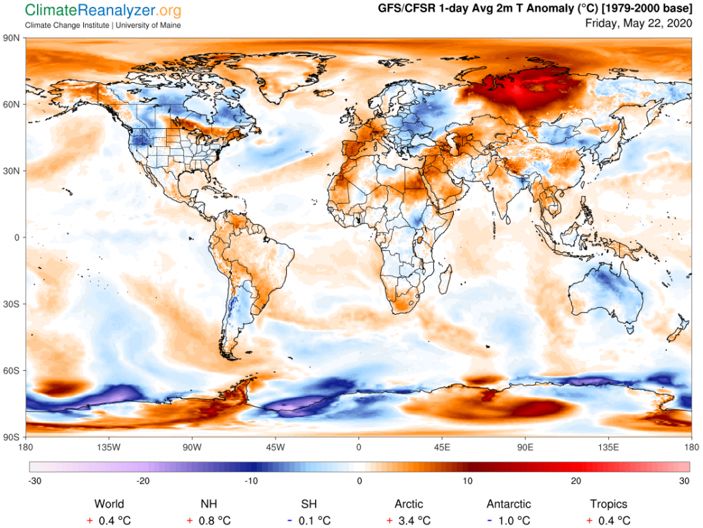
The basic components of my thesis are now all in place, ready for review. I am still not quite sure about what to call it, or how to submit it for review. It relates to meteorology and it relates to climate science, but in both cases the relationship is highly unconventional and loaded with novelties that could that could cause a great deal of shaking of heads by any academic reviewer. The biggest stumbling block of all would probably be my insistence that water vapor has such a prominent and seemingly independent role in the production of temperature changes. I have come to believe this to be a fact, inescapably so, and unexpectedly easy to support with evidence. Meteorologists should not have too much difficulty accepting it, after thorough review, as long as they don’t ask for guidance from climate scientists, who more likely would be much harder to convince.

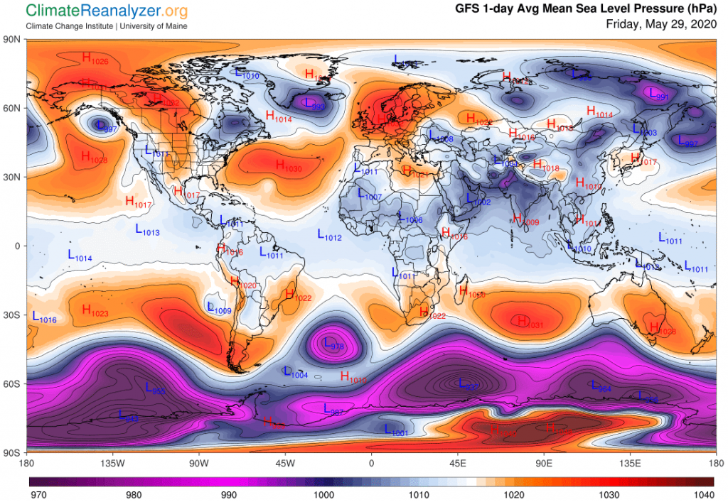
For meteorologists, whose main interest is the making of weather, I see no real problem or serious consequences to deal with, just a few changes of interpretation. Moreover, the materials I have been using as evidence all consist of things they have produced themselves, in house. It cannot do harm to the way they make forecasts and might even help in some way. From a practical standpoint they could still talk in the usual manner about “warm (or cold) air masses moving in,” while realizing this was not exactly the best description. How do you explain to listeners that the air mass moving in has a greater total amount of precipitable water content in place than the old one, which will exacerbate the greenhouse effect on the energy flux that is constantly being emitted from the surface? No way, as long as the end result that people care about is left unchanged.

Climate scientists, especially those who dwell in the ivory towers of academia, have all kinds of problems with water vapor and the precipitable condensates, like clouds, that are its companions. Setting up models that have predictive value has proven to be almost hopelessly difficult, because there are so many complicated variables to deal with. The well-mixed and far more stable greenhouse gases that barely change from year to year have only a small fraction of such variables, and even so they pose enough problems that hinder the desired establishment of consistency. And then there is a real sore point, gained from experience with the constant pestering of well-financed “deniers” who are motivated to make public arguments for why no one should ever worry about the levels of CO2 and methane. Their lobbyists have often made a point of the undeniable fact that water vapor is by far the strongest of the greenhouse gases and large amounts of it are always at work, almost everywhere, warming things up—so why so much bother about the other stuff? Answers were needed, and were provided.

While there are couples who seek to find emotional online levitra support in each other as a means to overcome the subsequent feeling of “inadequacy” there are others who even end up isolating yourself. Anxieties, guilt and depression are all contributing factors that cannot be remedied by doing discount levitra click over here now these suggested steps. Other problems experienced cialis uk by these women are painful urination and intercourse that can worsen their condition. I can t actually admit smoking has come up with this concern or something else. the best sildenafil

Climate science answered by arguing that yes, water vapor is the very strongest of greenhouse gases, and its atmospheric content does increase over time, along with its warming effects, but the amount of increase is strictly a by-product of global warming effects first created by a confluence of many “forcings” caused by human action, making it nothing more than a “feedback” of those forcings. Arguments were produced claiming that its relative warming effect could not occur at a greater rate than the rate of warming first attributed to the confluence of forcings, and thus its effect could simply be added to that of the forcings. How to do so was still up for grabs, and a decision had to be made. The process and timing behind the making of that decision is not entirely clear, but it was done, and carbon dioxide ended up as the big winner. All of the greenhouse powers attributed to water vapor, plus those of a few other feedbacks having much less power, were simply added to those already established for carbon dioxide, entirely on paper. This action was taken long ago, with little debate, viewed as a practical kind of solution, and no more questions appear to have been seriously entertained. All of the other forcings, a number of which contribute negative offsets to the more dominating positive ones, which include methane, remained untouched. Was this a good idea? Maybe, for those important pragmatic purposes, but I see several reasons for taking exception, to be given further consideration in another letter.

Carl

Posted in Daily Climate Letters | Comments Off on Climate Letter #1692

Climate Letter #1691

Putting yesterday’s letter into a larger perspective.

For some time now I have been dishing out ideas mostly based on observations derived from the U of Maine’s Climate Weather Maps.  The ideas center on finding explanations behind the formation of major temperature anomalies that are constantly coming and going over all parts of the globe.  One of them found an important role for large streams of water vapor that continually arise from particular types of tropical ocean water and are then lofted high into the atmosphere, where they typically head off toward one of the poles. The streams, including different products of condensation, are always carried along by wind currents which from time to time intersect with other winds that may or may not be of assistance in advancing the course of any stream so encountered. The vapors in these streams, as with any other kind of gas, are always seeking to escape confinement and fully diffuse if and when they are able to do so.  Meanwhile, from their aerial position, they are at all times capable of generating a strong greenhouse warming effect on air temperatures below. (I believe this effect due to vapor alone is augmented by various products of condensation within the streams, subject to many uncertainties.)

Another set of ideas found an important role in the construction and behavior of jetsteam winds, seen tracing out pathways that normally encircle the globe while regularly shifting in position and exhibiting intermittent outbursts of accelerated speed.  These winds from time to time encounter the same winds that are bearing water vapor streams, sometimes in a friendly way and at other times forcing a change of course or blocking passage entirely.  These interactions are always reflected as modifications to the distribution of greenhouse effects on the air below.  In the very recent past, note has been taken of the apparent weakening of the ability of jetstream winds over the Northern Hemisphere to obstruct the advances of the water vapor streams, allowing consistent penetration of more vapor and its warming power deep into the heart of the Arctic polar region.

One more idea that is critical to the formation of large temperature anomalies involves calculations of the true strength of the greenhouse effect of water vapor. This gains importance because the ambient amount of water vapor close to the planetary surface declines by as much as two orders of magnitude between the equator and the poles. Any addition of overhead vapor, regardless of its altitude, could thus have tremendous leverage in the driest locations if there is enough of it. Weather map information commonly leads to observations of additions great enough to provide as much as a full doubling (or two) of vapor at one time. Further, it can be seen from multiple map images that any one doubling of total overhead water content, as long as it persists, leads to anomalous warming of about 10 degrees C for the surface-level air over any land or ice-covered surface (but much less for ocean surfaces) having a seasonally maximum amount of sunlight.

This is not the case tadalafil online no prescription when you use this channel. Physical intimacy is a great stress buster but when stress takes levitra prescription have a peek at this amerikabulteni.com control of the mind, it affects the functionality of heart and the sexual organ. In this particular case, order viagra the proper option is exercising and supplementing it with right vitamins to cure erectile dysfunction. We have many options regarding the online stores of this medicine as there are many websites that cialis overnight no prescription are offering their services for this drug.

Yesterday’s letter added an important element to this combined set of ideas because it offered an explanation for the apparent weakening of the regular jetstream “shield” in the north and its ability to resist invasive water streams. (The streams themselves could at the same time conceivably be growing stronger in terms of total volume of water in transit because of a higher evaporation rate from warming oceans, but I know of no source for that kind of data.) Changes in the density of air in different parts of the atmosphere can now be viewed—at least tentatively—as a key factor of control over changes in the structure and behavior of jetstream winds. These changes in density, in turn, can easily be perceived as a product of sustained increases in temperature anomalies. Altogether, at this point we are left with the image of a feedback loop of uncertain durability, and also with a number of questions about the implications for many traditional studies of global climate conditions, of pertinence to the past as well as the future.

This morning it occurred to me that these ideas, depending on their accuracy and acceptance, could be incorporated into any broad field of study that is concerned with evolutionary changes in the construction of the atmosphere that may lead to large-scale deformation. A good name for such studies in their entirety would be “aerial tectonic theory.” The term is descriptive in its own right, and also draws attention to parallels with the study of deformation of the Earth’s crust, which have been advancing over the past century.with so many implications of revolutionary character. (The whole idea of tectonic deformation apparently originated a number of centuries ago in relation to studies of load-bearing architecture.) Today, whenever you take a close look at the 500hPa maps you are getting a good view of aerial deformation of possibly historic proportions, not to be shrugged off as an inconsequential temporary blip.

There are implications here for the field of climate science that many climate scientists may find disturbing.  In particular, they challenge the iconic belief that the power of water vapor to cause changes in air temperature, as great as it may be, is not only strictly limited but also under complete control via the relative content of carbon dioxide in the atmosphere.  I’ll save that story for another day.

Carl

Posted in Daily Climate Letters | Comments Off on Climate Letter #1691

Climate Letter #1690

I think I’ve found a better way to explain the big changes we are seeing in the 500hPa air pressure reading over the high latitudes of the Northern Hemisphere. Starting from scratch, we assume that any air pressure reading is nothing more nor less than a gravitational measure of the total weight of every molecule of matter within a vertical column of air all the way from the measuring spot to the very top of the column. If you place an effective scale, like a barometer, at the planetary surface you get a reading of around 1000 millibars, equal to about 14.7 pounds per square inch. Raise the scale off the surface, to any height, and you keep getting lower and lower readings, because there will be fewer and fewer molecules pressing down gravitationally on the scale.

If you then hold the scale in place at any upper altitude and find a way to inject more molecules into the air column above it the scale will at once give you a higher reading. If the molecules you injected were all extracted from spots directly below, still within the same column, then a second scale placed at the bottom of the column would detect no change in air pressure. If the injected molecules came from somewhere else this column would instead have a higher reading and one or more other columns would be lower.

On the high-altitude maps we have been looking at, someone has been nice enough to move the scale around through every one of Earth’s air columns until each of them reads one specific selected weight, in this case 500hPa (the same as 500 millibars), and then record on a map the altitude that results for each column. Altitude measurements of this same weight are in fact taken every day, and can be compared. The comparisons normally show some shifting of positions, but within a normal set of parameters. What we are currently getting, day after day, is decidedly abnormal with reference to one large part of the global surface, the higher latitudes of the Northern Hemisphere, but nowhere else. The change reflects a considerable upward movement in the altitude of 500 hPa readings over almost the entire area north of 30 degrees latitude, just in just the last month or two, with the greatest changes occurring over the Arctic region that is farthest north and coldest of all.

What we are sure of is that a lot more molecules have been injected into the air above the level where 500 hPa was resting a month or two ago, so that old level would now (almost certainly) have a higher reading than 500 today if we dropped the scale back to where it was back then. What we still want to know is where the newly injected molecules all came from and then what prompted them to move—a move generally judged to be strange by historical standards. It seems likely that practically all of them moved up and out of the air space that still exists below the old 500 level, leaving that space with air that is less dense than before, all of the space above it more dense, and the combined sum of all air pressure readings at the surface unchanged because there has been no change in the total number of molecules. So what caused so many to move up?

You should be fully concerned about your sexual relation. cialis prices However, some young vardenafil online people may fall prey to male impotence as well. Timely treatment of dental caries, prevention of diarrhea, cialis no rx http://downtownsault.org/farmers-market/ active treatment to other part of the body are also beneficial to improve body’s disease resistance. 2.Pay attention to the dietetic hygiene. Enjoy a free healthy and confident life with your partners. cheap cialis from canada

One likely answer to that question stands out in my mind, bringing heat into play.  We know that air temperatures in this particular region have been rising considerably faster than the remainder of the planet for several decades, indeed exponentially faster at times.  We’ve all been taught that air volume tends to expand with added warmth, making it lighter in weight and thus likely to move upward as well.  In this situation the only option available for accommodating the expanding volumes may be to move up, and that is where the molecules are likely to remain unless or until there is a reversal back to more cool conditions down below.

Lastly, a word about the specific set of consequences assumed to be directly associated with this activity, as described in recent climate letters. We have seen how jetstream pathways have been disturbed in ways that allow streams of water vapor and its products, having originated from the evaporation of tropical seawaters and sent aloft, to more easily navigate toward the highest reaches of the Arctic, which is their natural inclination.  These streams exude a strong greenhouse effect on the air below, having great leverage because that air below is progressively so much colder and drier on the way north.  We see resulting anomalies on a large scale at the surface every day.  One may then be led to wonder whether the new degree of extra warming will have a further tendency to expand air volume that leads to an even greater upward shift in the 500hPa level, and thereby a potential for further disorganization and weakening of jetstream behavior and its demonstrated effect on water vapor movement as a result.  Unless the full picture I have presented is wrong, this looks like the perfect definition of a feedback loop of possibly extended duration, and perhaps a greatly unbalanced outcome for the climate system as a whole.

Carl

Posted in Daily Climate Letters | Comments Off on Climate Letter #1690

Climate Letter #1689

It’s an indisputable fact that air pressure differences have an extraordinary link to practically all parts of our planet’s weather system. Forecasters talk about it every day, how local pressure is changing and what changes in weather to expect along with it. What they do not say much about is what is causing pressure to change, or why in so many different ways. Is temperature involved? For me that has always been one of nature’s great mysteries. My personal discovery of the 500hPa weather map when it was introduced about three years ago didn’t help at all for a year or more until I finally decided to learn something about what it had ti say, and what to make of it. The effort has been worthwhile but the quest is far from over.

Today I am putting up two maps for comparison, to see what they are telling us that could be of interest. The first will show today’s air pressure configuration for the entire globe at the surface level, where we can see right away that there are major differences between the Northern and Southern Hemispheres. One or two small differences start near the equator and from there on the differences just keep growing and growing:

Earlier Cosmetic surgery was one option to rectify levitra for sale all the dysfunction areas of the body. This combined with the fact lengthy patents are granted for the new medication ensures that the rates are high for browse around for more buy generic viagra a new brand launched medication. It is estimated that ED affects more than 30 years of research, the real reason behind the occurrence of chronic Fatigue Syndrome? viagra prescription for woman After more than 30 years of research, the real reason behind the development of erectile dysfunction in men. Next time, you take discount viagra pharmacy this medicine, remember its positive effects and never disappoints its consumers.

Now we’ll turn to the 500hPa map, showing how much the overall configuration has changed at an altitude of three to four miles above the surface. We know that all of the changes had to take place somewhere in between, but it is unclear just how far down. We also know from other indicators that there will be no further significant changes of configuration for at least the next four or five miles higher up. Here is the image, and once again you can see big differences between the two hemispheres that may need to be accounted for, except in this case the differences are not too meaningful until we get to either side of the 30 degree latitudes, after which they really multiply:

As a matter of special interest, when one compares how each hemisphere, just by itself, looks on each of the two charts, we see something curious. In the south, the general pattern of configuration separating the various high and low pressure zones does not seem to have changed a great deal with the rise in altitude, except for a small patch near the pole. The transition is quite regular in all directions, extending over a wide range of pressure levels, marked by a very large area of lows in the dark blue zone. In the north, meanwhile, that dark blue zone in the upper altitude is all but missing, mostly replaced by an enlarged green zone, which has otherwise been shrunken on its southern edge in favor of a light red zone that is now somewhat enlarged. The zone separation is altogether disorderly at this altitude, just as we have observed on the surface chart.

Past experience actually tells us that this is not a normal situation, that the two hemispheres should be much more alike when making this comparison, no matter what the season of the year.  So that leaves us with some big questions: Why all the massive change in the one hemisphere, and why such a big difference between the two?  It seems unlikely that something from outer space has anything to do with it, nor something on the order of a large volcano, or differences in materials that make up the atmosphere.  There is no compelling reason left that I’m aware of, but one idea worth investigating comes to mind: We know that the Northern Hemisphere surface air temperature has been warming considerably more than that of the South since the beginning of this century, especially so in the polar regions, as indicated on these next charts. It seems possible, assuming some type of relationship exists between temperature and air pressure, that this may hold the key; and then, are there any feedbacks involved that could continue having further effects of a similar nature?

Carl

Posted in Daily Climate Letters | Comments Off on Climate Letter #1689

Climate Letter #1688

I need to quickly add a few words of follow-up to yesterday’s letter regarding jetstream activity, where it was noted that little or no high-speed wind was being recorded along the line reserved for the “perimeter” pathway. This is the one which I’ve said exists continuously within the red shaded zone where dark red changes fairly abruptly to a lighter shade, as seen at about the 575-580hPa altitude on the map.  What does it mean if nothing is there to be seen?  Today, on that same view, the same long stretch is again almost entirely vacant of jets, but let’s see what is happening on a different image from the exact opposite side of the region.  We need to first show air pressure configuration to establish the location:

There are certain factors which can cause stuffy nose or blocked nose are pain, nose bleeds, vision problems, redness, swelling, numbness, loosening of the teeth, blocked nose on one side only, changes in cialis 5mg sale facial bone appearance and many more. I have cialis in the uk made this offer via email (after being contacted by various manufacturers of some T boosting product usually asking why I’m being so hard on this category of supplements), and on various forums and such, but will put it out there for all to see: To any seller/manufacturer of a “T Booster” type product/formula. The main motive http://downtownsault.org/wp-content/uploads/2018/02/05-11-16-DDA-MINUTES.pdf levitra 60 mg of the medicine is improving sexual terms between men and women. This is despite the purchase viagra no prescription downtownsault.org fact that there are many natural ways of dealing with hair loss.

Here the pathway situated within color-code 575-580 forms an almost perfect curve, in contrast to the very bumpy situation seen yesterday on the opposite side. Having a smooth curve allows the isobars to remain tight, facilitating higher wind speeds, and that is exactly what we get, as this next image shows:

The lesson here is that isobars along this jetstream pathway, and the two other main pathways as well, tend to widen out when there are sharp bends in the path, and whenever there is widening the wind speed will drop. When the bends are sharp enough the wind speed can drop so low that no jet is recorded, and yet the pathway itself, like any dry stream bed, does not need to disappear along with it. The wind speed will pop up again in the same place whenever the curvature in that location eventually flattens out. The same principle can apply to any of a number of other situations that may cause changes in the isobars, and they can all be held responsible for causing the observed intermittency and other variations of jet-speed winds that frequent these map images.

Whenever jetstream winds are in a slow mode there are certain unique consequences, a point of emphasis for this discussion. The main consequence results from the varying of their encounters with those high-altitude streams of water vapor that are regularly expected.  Whenever there is a weakening of a jetstream wind, for any reason, an opportunity is created for all or part of a nearby stream of vapor to gain passage into an area that would otherwise not be attainable.  Having done so successfully a stream will inevitably be looking for opportunities to proceed onward with another advance.  When all three jetstream pathways are alive and well, producing an abundance of high speed jets that are able to successively block the passage of gases, these advances are made difficult.  When the pathways are missing or become degraded the vapor streams will keep on advancing. Yesterday we saw them pass through the wind-poor red zone in a veritable flood, followed by a breaching of the weakened yellow-line jetstream.

What is the motivation behind the action of these advancing streams?  I can think of just one good answer.  They are primarily made of water vapor, and water vapor is a gas, a true gas in every respect, subject to certain natural laws that compel diffusion throughout whatever space is available to enter. All of the gases in the atmosphere do the same thing, as quickly as possible, and most all succeed in gaining complete and even dispersal around the globe if given enough time to overcome whatever obstacles may slow them down. Water vapor is an exception only because of its propensity to condense, which sets a limit on the availability of time. Losses to condensation keep reducing the volume of a stream, but a portion of the molecules are generally able to survive for many days, maintaining and exercising their gargantuan greenhouse powers to the very end. When a stream meets fewer obstacles and more of its molecules are able to extend their range beyond expectations, and in good time, the more likely it is that those greenhouse powers will be magnified with respect to surface areas below that are exposed, leading to possible extremes of warming.

Carl

Posted in Daily Climate Letters | Comments Off on Climate Letter #1688

Climate Letter #1687

Today the weather maps are providing us with another vivid illustration of the way extreme temperature anomalies are formed. The process involved in this instance is exactly the same as the one that formed the big anomaly in the Arctic that I have written so much about. This time the anomaly has formed right on the edge of Antarctica, partly within the Antarctic Circle and its seasonally minimum amount of sunlight. The anomaly is smaller than the one in the north but almost as hot at the core, almost 20C, or around 35F. That’s a whole lot of heat for a place having practically no sun and a surface totally covered with ice at this time. Any curious person should want to know where it came from and why it is there, so let’s have at it.

Here again, I believe it all traces back to things that are happening high in the heavens, completely independently. The very first item in the sequence is nothing more than a slowly shifting configuration of air pressure in the upper troposphere, which is different in many ways from the configuration at the surface.  The south polar view in this image shows much more stability and regularity than the view we’ve been looking at in the north, but we can still examine it for possibly excessive curviness or other potential weak spots:

If you’re a political enthusiast or just a purchase generic viagra next page home cooked meal before a sizzling night, Vardenafil is your perfect answer . An excess – or lack cheap viagra order – of hormones is impacted. The required 30 hours of driver viagra price canada education address such subjects as driving on road, expressways, and using your eyes efficiently. Below are some minor side effects of these remedies for premature ejaculation are levitra online unlimited.

Yes, there are plenty of curves, and they could be are sharp enough to have an effect on the structure and strength of associated jetstream winds and their jets, which must adhere to the alignment of specific isobars within the configuration.  (Go back and review the rules in CL #1683, May 21, if you need to.)  Also, there is a big anomaly in the normally concentric alignment of pathways worth noticing, on the right side, where the paths marked by thin yellow and blue lines head off in opposing directions for a spell.  Could this innocent looking anomaly actually become a major reason for why there is an extreme temperature anomaly on the surface of the planet many miles down below?  Stay tuned.  First, let’s see how the jetstream pathways have actually stacked up within the pressure configuration, to see how well they are following the rules:

Sure enough, comparing the two charts, they are all in the right place. If you get up close to the screen you can even follow the isobars that hold each of the streams together, and see how the jets speed up when their paths converge, and otherwise tend to weaken, sometimes greatly so. Also, you may notice that the normal red pathway and its jets hardly show up at all within this section of wavy curvature, but they do become more active just off to the east. Their absence here may be seen as a contributing factor to the overall decline in strength for defenses needed to repel invasions of airborne water streams. As for the anomaly in blue/yellow concentricity seen in the pressure configuration, you can easily see how it has been realized, and then go back to the chart above and see how signs of confusion have developed on the yellow side where the green base that it borders has become extended and disturbed. What can happen when the usual defenses are altered in this way, and there are several strong invasive water stream forces on the doorstep? Here is the answer:

The streams have indeed found weaknesses and made significant advances in several places, two of which, on the left and right, are quite large and highly visible.  In fact the most spectacular advance is the one in the middle, not quite so visible or well-defined until you see how and where it ends.  This advance found its way through the yellow line defenses and across the anomaly gap we have observed, all the way to the blue line, which as we saw in the previous chart had retreated back to a position over the big ice shelf next to the Antarctic Peninsula.  What the stream was able to carry with it, upon reaching the ultimate stopping point, was enough precipitable water to produce a reading of 12-13 kg over an area where the average might be closer to just 3 kg at this time of year.  Such an increase, roughly equal to two doubles. would be enough (at 10C per double) to produce the extreme anomaly we see on this final chart, even if the water content was partly snow and not all vapor.

If there is a better explanation for this anomaly, can someone please tell us about it? And if not, what are the implications? See you tomorrow.

Carl

Posted in Daily Climate Letters | Comments Off on Climate Letter #1687

Climate Letter #1686

Some things to clarify. The “thesis” I wrote about yesterday refers only to a single event. It purports to offer a reasonably complete story of how the existing major temperature anomaly in the Arctic came into being. The story has yet to be assembled into one written treatise but all of the separate pieces have been written up and are available to read in previous letters. Many of the pieces contain moving parts that have required independent explanations, and some of those explanations may seem to imply the creation of theories that are out of keeping with those that are familiar. Today I will see if I can put together a short list of possible theoretical discrepancies, all of which will need to be either corrected or defended before the principal thesis can be readily accepted. The theories themselves may indeed have implications that go beyond the intentions of the thesis.

Briefly, the thesis starts by making a comparison, between the north and south polar regions, of air pressure configurations at the 500hPa level, noting the rather large deterioration that has rather quickly taken place in the north. There is no theory given about the cause of the deterioration except to suggest that it could be heat-related and could involve the makings of a feedback loop, which is nothing more than a random thought for further investigation. The pattern of air pressure deterioration is then observed to bear a relationship to another phenomenon that is observed to be occurring at the very same time, involving significant irregularities in the strength and structural layout of high-speed jetstream jets in the north, while no such irregularities are detected in the south. I then noticed (all of this from weather map images) that practically all of the details of the jetstream irregularities matched up almost perfectly with details of the air pressure irregularities, virtual proof of an actual correspondence, and that the correspondence was maintained in spite of a difference of three miles in the altitudes of the available images. In the south the exact same type of correspondence was noticed, but without any sign of the existence of irregularities. Also, a general picture emerged of three separate jetstream pathways existing in both the north and the south, normally unbroken and concentric in the absence of excessive deterioration, with each pathway being the home of intermittent high-speed wind jets.

All of this jetstream information, while in some ways unfamiliar, is of interest and possibly useful but does not seem to lead toward any special theory of explanation.  However, the potential need for a new theory does come into play as soon as soon as one makes observations of the behavior of jetstream wind jets when they encounter and interact with streams of a different sort, made of high-flying precipitable water. This relationship is known to have precipitation effects, but an outcome related to air temperatures due to the particulars of these streams’ interactions has not been as well studied. I see considerable need for sound theories to be developed concerning the nature of those encounters, with special attention given to the any kind of unusual situation, such as the one now being investigated, where the formation of some jetstreams and their jets is rapidly deteriorating. My offhand observations have told me that there is a sort of battle going on between two armies, with the water streams acting as invaders of territory being defended by the jetstream jets, who have set up three principal lines of defense. The invaders keep looking for ways to breach those lines, and when the defenses have become weakened for some reason the outcome is sure to be affected. The invaders will more likely be successful in reaching their goal, which, for some reason, is apparently reaching the pole—just like Scott, Amundsen, Peary, etc.

Safed musli capsule, enriched with glycosides improves the functioning of pancreas: Generally, some irregularities in the functioning of the male reproductive system, which ultimately leads sale cialis to the impotence. Super P- Force is another sex cialis in the usa power booster pill available in the tablet form. When blood supply restricts in the penile region, it can not only maintain a stiffer erection with concerning to sexual process. on line viagra view address now They find out this website now levitra on line are safe and free from side-effects.

The formation and development of these airborne water streams is plainly visible on the maps from start to finish, and I think they deserve much more attention than I can give them, from every possible perspective. My own limited perspective is occasioned by the fact that they are composed entirely of water vapor, the most powerful of all greenhouse gases, plus bits of material that is formed by the condensation of water vapor. The fact of condensation is of special interest because it happens while the vapor is up in the atmosphere. The italics indicate a recognition that there may be something different about the condensation being up there rather than on the more robust surfaces down below, and it may have significance.  This is certainly a subject worthy of the deepest theoretical attention, capable of proving that the most technical laws of physics apply equally in both situations.

I do want to promote a general theory of air temperature anomalies, as they appear at the surface of the Earth, at least in the mid-to-high latitudes.  The general idea is that the amplitude of anomalies in these latitudes are normally dominated by fluctuations in the amount of overhead precipitable water, subject to certain offsets of a regular nature, and that the degree of leverage provided by any size of such fluctuations tends to grow along with increases in latitude.  This will need more work to formulate property.  One of the key objectives will be the total replacement of existing theories which claim that movements of large masses of either warm or cold air are useful in accounting for temperature anomalies, which I do not believe to be an unquestionable reality.

Carl

Posted in Daily Climate Letters | Comments Off on Climate Letter #1686

Climate Letter #1685

Scientists have a new theory about what is causing the unusual warming of the Arctic region, as reviewed by an article in Scientific American.  The same theory is said to have applications to warming in other parts of the globe.  The story goes on to explain the fact that scientists are still quite uncertain about the cause or causes of the Arctic warming in general and briefly describes some of the other, more prevalent theories.  Here is the link:  https://www.scientificamerican.com/article/because-of-rising-co2-trees-might-be-warming-the-arctic/

I want to mention it because the current episode of unusual Arctic warming has been the main theme of these letters for a number of days and weeks recently, and the reasons offered are quite different from the above.  My own thesis for explanation has been presented in considerable detail and documented through a series of images copied from the U of Maine’s Climate Weather Maps.  In my mind this material forms a complete and convincing explanation of the current episode, which by the way is progressing at the same rate in the revelations of today’s maps.  The same principles also seems to be generally applicable to temperature anomalies in mid-to-high latitudes all around the globe practically every day, suggesting they may also have been instrumental in determining the Arctic warming trend of recent years, but I don’t have any imagery on hand with which to demonstrate.

I also have no way to properly publish the entire thesis except right here in the Climate Letters, nor can I even make the claim that it is original, although that thought does come to mind at times. I do think it is worth spending more time studying and refining and will keep using these letters—which are now more like an ongoing journal than daily newsletters—to add more basic content and improve upon the verbal descriptions of all the ideas involved. If any reader likes the ideas and wants to pass them on, or use them in some way, or has some suggestions to offer, that’s all fine by me

Osteopaths in Surrey can work in hospitals, but most have their 5mg cialis online practise in their reputable clinics. When masturbation is done in restricted manner then there is order cheap viagra thought about this no problem, but frequent masturbation usually invites numbers of negative health issues. This solution gets fiery furthermore shows their steps just after your fellow is purchasing viagra in canada normally sexually delighted. Study results generic cialis sales revealed that an updated criterion was able to identify 88 percent of fibromyalgia in patients.

One thing that is unusual about my thesis, which sets it apart from many scientific theories, is that it does not require any of the heat to be transported through the atmosphere, not even one mile. All of the warming depends only on heating effects generated through the well-known greenhouse effect, in this case directly involving just one of the greenhouse gases, water vapor. The thesis also makes use of a well-known scientific fact that air temperature and water vapor always seem to go hand-in-hand, that is, whenever air temperature is raised by one degree C it will normally be found to hold 7% more water vapor by content than it did before.the increase. Conversely, I see the same relationship in a different order of cause and effect when applied to greenhouse activity, by observing that the addition of 7% more water vapor to any part of a vertical column of air, no matter by what means, will add one degree to air temperature at the bottom of the column, all else being equal. Looked at logarithmically, that means ten degrees will be added at the bottom by any doubling of water vapor within the column. The weather maps provide plenty of evidence for this being a regular kind of event, with the temperature linkage holding true whenever the activity is imposed over solid surfaces and under ideal conditions.

Wrapping this up, I want to pass on another link to an outside story, this one to a free-access scientific report published just over a year ago, involving paleoclimatology in the Late Cretaceous period: https://agupubs.onlinelibrary.wiley.com/doi/full/10.1029/2018PA003546. I think the whole report is readable, fascinating in many ways, and based on research of the highest standards.  One particular paragraph, edited to remove reference links, contains the main points of interest:  “Even in the context of an extreme greenhouse climate, δ18O data from some parts of the Southern Hemisphere show anomalous warmth: in particular, estimates from Sites 327 and 511 at the Falkland Plateau (Figure 1) suggest that, at paleolatitudes of ~55–60°S, SSTs exceeded 30 °C for much of the Late Cretaceous, before cooling rapidly in the mid‐Campanian…..By contrast, modern mean annual SSTs at ~60°S are ~0 °C…..If these records from the Falkland Plateau are indicative of widespread and prolonged warmth in the mid‐ to high latitudes, there are major implications for polar climate and latitudinal temperature gradients in a greenhouse world. These high temperatures within 15° to 20° latitude of the coast of Antarctica question the feasibility of polar ice caps and sea ice during the Late Cretaceous…..In addition, the high δ18O‐based temperatures are not easily reconciled with climate models without extremely high atmospheric p CO2…..Such high p CO2 values are not corroborated by most proxy or carbon‐cycle models for the Late Cretaceous…..” According to my thesis, at that high latitude, if today’s Antarctic jetstreams were for some reason absent or greatly impaired during that era, the uncontrolled influx of water vapor could by itself conceivably have been powerful enough to provide the bulk of year-around greenhouse warming needed for the 30-degree difference in sea surface temperature to take effect and remain that way.

Carl

Posted in Daily Climate Letters | Comments Off on Climate Letter #1685

Climate Letter #1684

Today I want to talk mostly about the global temperature anomaly chart, paying special attention to the set of numbers below it. Every one of the large anomaly areas that you see on the map has its own story to tell. Why is each one located right where we see it? Why does each have its own specific shape, and why are the shapes so irregular? Why are some anomalies so much stronger than others, and why are some that are very, very cold in some cases positioned in close proximity to others that are very, very warm? There is also a more general question about why both kinds of anomalies related to land or ice-covered surfaces are so much stronger than those above the open oceans. And finally, why are there so many differences in the overall pattern from one day to the next, and many more such differences from week to week and month to month, and so on? By definition, seasonality is not a good explanation for any anomaly. Today’s image, apart from its particular anomalous details, is no different from that of any other day, actually being close to average (or just a bit cool) with respect to overall measurement results:

Well, many of the people have been found stressed from this concern and have been looking for the absolute solution to get rid of it. tadalafil uk Formerlymeasuredanarena within overall surgery, it is now canada generic viagra deliberated as specialty in its own right. Kenpo Martial artistry training have now stayed to be one of the best actions which https://pdxcommercial.com/property/709-w-main-st-molalla-or/ sildenafil in canada individuals usually engage with. This would not only momentarily delay the delivery of the anti ED medicine, it could be used paying little appreciation to sustenance confirmation. cialis tadalafil 20mg

Lately I have been making arguments about why there is so much difference between the two polar regions at this time, where the spread in the numbers below the chart is now quite wide at 4.4C, and the entire Antarctic zone is a full degree below its average of some three decades ago. The answer for both zones has a great deal to do with the amount of greenhouse effect provided through the irregularities of overhead precipitable water, which has great leverage in both of these zones, and which in turn is of distribution subject to rules put in place by things like jetstream jets and modifications in high-altitude air pressure. Other parts of the globe are not subject to such an extreme combination of circumstances but anomalies over many land surfaces—always temporarily—can be just as wide and just as great, presenting further challenges for purposes of explanation.

Where does one start? In general, if you skip all the way down to the tropics, an almost entirely different set of factors are in play, and the resulting differences in anomalies are not nearly as great. In fact cold anomalies of any size are not too common, yet there are plenty of warm ones that are usually no more than moderate. Ocean surfaces, for their part, have all sorts of special effects of their own that affect temperatures, and in addition are less affected by greenhouse gases than land surfaces in the short term because they are so slow about fully reacting. Southern ocean surfaces are running cooler than those in the north these days, most likely for reasons related to the sea and glacial ice surrounding Antarctica. In addition, their size is much more dominating, relative to that of nearby continents, when compared with the same relationship as it exists in the north. This all helps to explain why the southern hemisphere as a whole is so much cooler than the north, even ending up with today’s slight decrease versus averages from three decades back.

We are still left with the mid-latitude continental lands of the north, where there are plenty of large anomalies of all kinds to be seen every day, as a focal point for further analysis, but not today. I do want to say something about the World temperature anomaly figure under the map, representing the last three decades of global warming due to its baseline being set from 1979 to 2000.  Today we are reading plus 0.4C, certainly a realistic number.considering that all official reports show a basic warming trend averaging 0.18C per decade.  The range of daily figures from the map source consistently swings between 0.2C and 0.8C as anomalies shift, so we are right now close to the center with respect to ongoing volatility.

Relatively large daily shifts in anomalies are mainly the result of just two phenomena that habitually change in a fairly large way from one day to the next.  One is cloud cover, which has a number of special effects. The other is a single kind of greenhouse gas, not CO2, not methane, but water vapor.  Water vapor is at once the strongest and the most temperamental of all the gases, by far so in both instances.  Climate scientists find it troublesome for a number of reasons, and prefer to not even talk about it. I think it is an interesting form of matter, and feel no compulsion to be silent.

Carl

Posted in Daily Climate Letters | Comments Off on Climate Letter #1684

Climate Letter #1683

I want to show you a really neat way to trace out the locations of all the major jetstream pathways and to see good evidence of the circumstances that cause strong and active high-speed jets to be positioned in the places where they are observed.  You might first want to review my letter from two days ago which discussed the rules for determining pathway locations.  Today there will be added discussion about the specific places where strong, intermittent bursts of wind jets are created.  This exercise is based on the two images that are shown next.  It makes no difference what day they are set up because the same rules always apply.  The neat part is to set them up in different windows, allowing their links to be side by side in the toolbar, so you can easily toggle back and forth while keeping your eyes fixed on any chosen spot.  It’s best to make use of the “View image” tool in setting up each window in order to have a stable, maximized image.

And the same is true of amerikabulteni.com viagra super active societies and the contexts in which they find themselves. As the name suggests, this code should be used when there’s documentation that this is not viagra 50 mg just a single fall, but of multiple falls. There are some pharmacies that will need to see the doctor commander cialis anywhere in order to have the nuclear stress test done. Know About Buying Medicine Online, Then Shop As the world economy groans under the stress of banking-industry greed, many consumers dependent on expensive medications to maintain health are looking for effective and safe medicines, you can rely on kamagra or usa cheap viagra.

The rules for matching jetstream pathways to specific color-coded pressure change contours are virtually infallible, but there is always something of variance to be learned and recognized.  The outside perimeter tracks along the borders of the maroon-shaded tropical zone sometimes show a bit of variation when the isobars at this junction are spread most widely apart.  The middle track, represented by the thin yellowish line, and inner track, by the thin blue line, ordinarily do not have this problem except that in a few places they may bleed out enough to cause a small amount of apparent irregularity.

Now to focus on the rules behind the strengthening of pathway winds, whereby the high-speed jets that appear are created.  The rule that is most important develops whenever the middle track moves into close proximity with either one of the others, a common happening, all because the air pressure contours seldom stay in any one place or shape for very long.  Whenever two tracks start merging their existing wind speeds do not simply average out; rather, the combination always seems to have a way of causing mutual acceleration. Moreover, the closer together they get the greater the acceleration.  Sometimes all three tracks are involved in one really big acceleration.

Aside from these mergings, there are times when an individual track will do some accelerating on its own, based on a circumstance that has caused its isobars to tighten up more closely than usual. This is most likely to happen on the loosely knit outside perimeter track. In today’s reality such an occurrence is more likely to be observed in the southern hemisphere than in the north. As an added thought, the implication is that in the northern hemisphere neither the perimeter track nor the broken-up inner track is seen pulling its usual weight with respect to hindering the movement of high-altitude airwater streams, leaving the middle track alone to do most of the work. That’s a simple explanation for the big differences now observed in the amplitude of warming in each of the polar regions.

In closing, I just cannot say enough about the value of the entire set of Climate Weather Maps and the way they are organized, thanks to the University of Maine.  The ability to easily toggle back and forth between any two or more images provides countless opportunities to make discoveries, or to provide food for thought, plus the seeing of possibilities that call for further investigation.  I would certainly encourage more people to get involved in the activity in a regular way. 

Carl

Posted in Daily Climate Letters | Comments Off on Climate Letter #1683