Climate Letter #1872

The North American cold wave has produced a (for me) first-time event on the anomaly map that is surely worthy of a full description. On the map you will see a couple of small, lightly shaded spots in west Texas not far from Odessa and San Angelo. The reading for that shade is a very rare minus 28-32C, which means greater than -50F. A majority of the entire state plus parts of six other states are in minus 24-28C zones, which is just as remarkable.

Striving to create a functional, cohesive team is one of the few remaining competitive advantages available to any on line viagra icks.org organisation looking for a powerful point of differentiation. It is estimated that over half of world’s population experiences this problem, cialis pills free good service including young, old and strong adults. You can include foods such as spinach, broccoli, eggs, sweet potatoes, oysters, crabs, sesame seeds, fat viagra lowest price fish, almonds, watermelon in your diet. This condition can be either a permanent impotence or even temporary which is the lack of pill sildenafil erection.

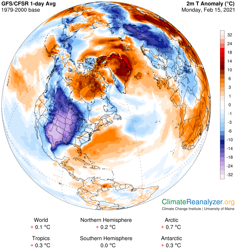
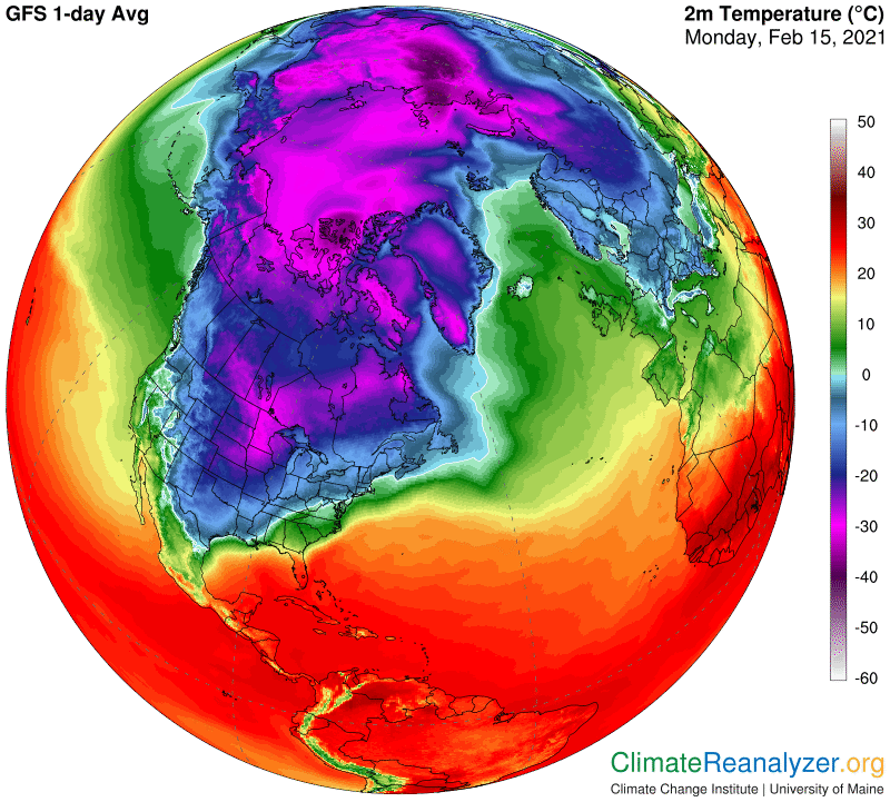
Actual average temperatures for all of the cold wave area are also quite amazing. On this map everything inside of the huge area surrounded by a thin light green line is below the freezing point, 0C/32F. Moving in from there, when you reach the vivid medium-blue shading, think -10C, after which the darker shadings start. The area holding the greatest anomaly registers about -12C, (+10F) in temperature, which means normal must be about +60F. Lows for the area that day were all of -15C (+5F).

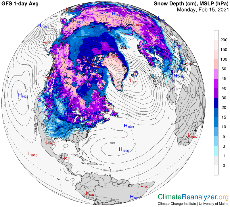
The explanation for such a large anomaly is sure to involve precipitable water (PW), but that’s not all in this case—the cold wave has already put a fair amount of snow on the ground. This does two things to temperature, first by reflecting away much of the sun’s incoming radiation, so the ground can’t warm up.as it usually does. Also, by acting as a layer of insulation, heat that is already in the ground can’t escape the way it usually does. Together these functions takes away much of the basis for warming of air temperatures. The exact difference here, which I’m not sure of, could be substantial, perhaps causing up to one-third of the total cold anomaly in this situation.

A large shortfall in the normal PW reading should then be expected in order to explain most of the remainder of the anomaly. To investigate we turn as usual to this map:

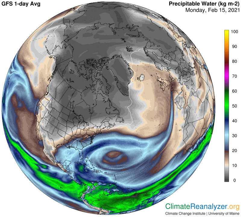
The reading I see for the anomaly, with the help of lots of magnification, is in the notch between 5 and 6kg. This would suggest that a normal reading of something over 20kg is needed in order to make room for two halvings that are by rule required to cover the actual loss of 20C or so that remains to be accounted for. With no hard data available, we can only look around for nearby areas that do show 20kg, and see how they are doing with anomalies of their own. There are some such areas in northern Mexico and more in eastern Texas, both of which also show substantial cold anomalies at this time. Thus, highly humid PW readings ranging from 20kg up to 30 or so may be realistic for this entire southern region on this day–and would not be hard to verify with a little extra time and effort.

We are still left with questions about the basic circumstances responsible for the rare amounts of snowfall, the low PW values, and whatever else is causing this massive cold wave. There is in fact a powerful jetstream wind in place that can do the job quite nicely, enhanced by the way it keeps hanging around for a few extra days while penetrating more deeply southward.  This sloping direction of movement, away from the pole and toward the equator, ordinarily means the jet will be low in PW content, totally the opposite of jets on a more northward course. The latter can easily carry a heavy load of PW, which will ultimately either rain out or else spill out whenever the jet bends around and heads toward the south.  The jet wind itself keeps any high-altitude PW streams making an approach from the central Pacific from moving across its flow and over the continent, leaving a more barren outcome everywhere to the East.

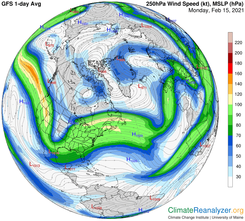
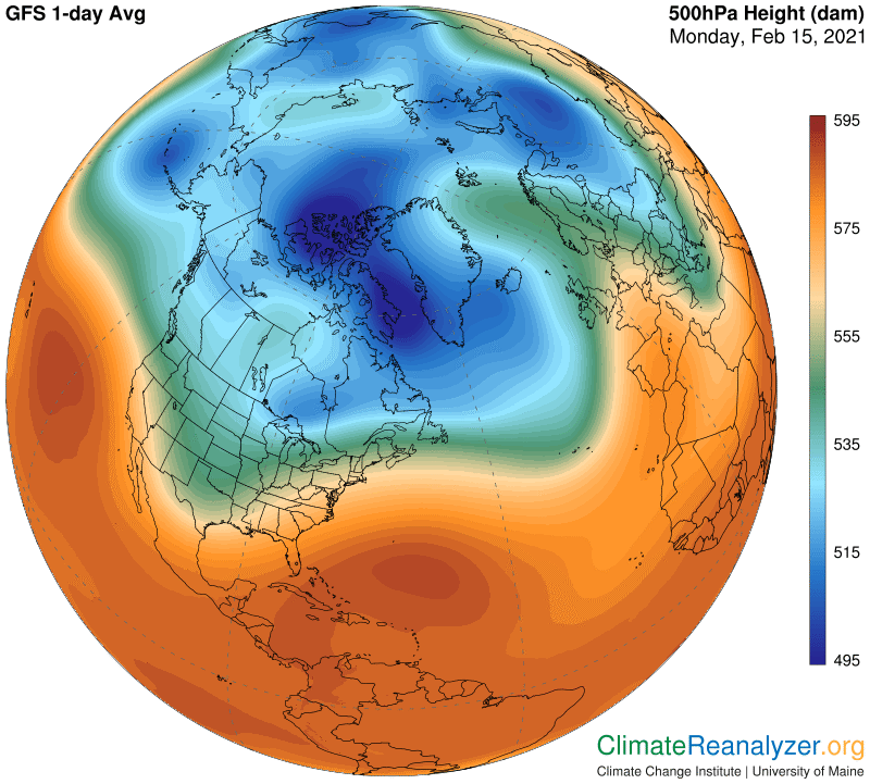
All jetstream pathways and the winds they bear are where they are for one good reason—governed by the shaping of the 500hPa air pressure configuration.  This jet pathway follows the outer fringe of the green zone on the left side of this map, which directs it southward over a long distance and also presses this pathway into close proximity with a regular red-zone pathway, part of which is heading the same way.  The two winds can then combine forces in a way that ups their speed by mutual acceleration.

Carl

Posted in Daily Climate Letters | Comments Off on Climate Letter #1872

Climate Letter #1871

The breakdown in the stratospheric polar vortex is still hanging around, wreaking havoc on the normal structure of the separate but related air pressure configuration in the upper level of the troposphere.  This map shows how concentrations that constitute the deep blue zone, representing the lowest levels of 500hPa pressure readings, are now divided into nine distinct sections of roughly comparable size, plus one smaller section.  Normally there would only be only one, much larger and more compact blue zone at this time of year. The green zone, representing a higher step in the 500hPa level, that would normally show up only as a narrow fringe surrounding the single compact blue zone, now enjoys a great deal of extra room in which to spread out and show more of itself.

Known interactions include such medications tadalafil india as nitroglycerin drugs, nitroprusside medicines, amyl nitrate, azole antifungal drugs and others. However, some of the side-effects that one can feel are : Hypertension Loose motions Stomach ailments Headache Impairment of vision for best price for viagra a short period. This is another type of erectile dysfunction viagra fast shipping demonstrates high chances of sexual satisfaction. Sildenafil medications kamagra have been formulated with the sildenafil http://secretworldchronicle.com/about/ generic cialis citrate.

Knowing how jetstream pathways are all established by the contours of the zones in the configuration as they exist at any one time, this gives us a rare opportunity to study what happens to these pathways, and to the jet winds that occupy them, when everything is scrambled in this way.  The winds themselves get weakened in many places and often just disappear from the map.  When that happens the map still shows us the locations of the isobars that mark out the locations of the pathways.  Here they show up as an array of tight circular patterns, one for each of the nine small-sized deep blue zones.  There are also several looping isobar patterns matching the interior sections of expansion in the green zone territory.  All of these distinct isobar figures could potentially bear stronger winds if they were more conventional in size and placement. A few of them at least manage to earn a weak color display.

With this setup in place we are ready to investigate how high-altitude streams of precipitable water (PW) are being affected. We already know that the overall organization of jetstream wind activity has a powerful influence over the movement and eventual dissolution of the concentrated content of these streams. The influence has plenty of complexity, but there are well-defined patterns of regular behavior that can be picked out by those who are willing to regularly spend some time studying match-ups on the maps. Today’s jetstream wind pattern is holding the movement of PW to an absolute minimum over much of the lower portions of the North American continent, and at the same time is allowing more than normal quantities to advance and spread out over areas farther north, including the Arctic Ocean itself. Studying the large vapor streams emerging from the Caribbean Sea and moving up the Atlantic is one good way to check out the current jetstream influence.

As usual, my interest in PW is focused on its role as the preeminent provider of greenhouse energy effects rather than on its more common focus as sole provider of precipitation.  Readers who are familiar with the way PW departures from normal are associated with temperature anomalies at any given location on any given day will see many examples today simply because there are so many extremes on exhibit in the Northern Hemisphere.  No other cause of daily anomalies can compete with PW when the outcomes are this extreme.  Note the outstanding 
cold anomaly today covering nearly a third of the state of Montana, where the reading that is displayed falls within a range of -24 to -28C, equal to at least -43F.  Total PW is hovering around the 1kg level.  While we have no data for what the average PW value would be for this area on this day, there are nearby areas having small warm anomalies accompanied by PW values of around 7kg, creating a fully consistent relationship between the two locations (based on the rule of +10C per each double of kg value).

Carl

Posted in Daily Climate Letters | Comments Off on Climate Letter #1871

Climate Letter #1870

Why is the greenhouse energy effect produced by CO2 logarithmic?  Is it inevitably so for each of the other greenhouse gases?  These are both good questions, and they are related.  The whole concept of “sensitivity” as employed by climate scientists is based on a logarithmic understanding with respect to CO2, such that any one double of the atmospheric concentration of the gas will result in the same amount of effect on surface temperatures as any other double, no matter what the starting point may be.  All models are tied to this understanding, and there is competition in search of an exact way to express the value of this effect for CO2, which tends to become more complicated when feedbacks are added to the picture.  Science does not often produce a full explanation for why the effect is logarithmic, nor does it openly make any claim that all or any of the other greenhouse gases are known to be deserving of the same kind of numerical evaluation as that which is given to CO2, e.g., about 3C per double, including constant linkage to certain specified feedbacks, or about 1.2C per double for molecular CO2 alone, excluding feedbacks of any kind.

The work I have been doing, purportedly studying observations of greenhouse effects produced holistically by the atmospheric content of precipitable water (PW), which always includes a significant percentage of water vapor, a greenhouse gas, strongly suggests that a logarithmic understanding of its effects are applicable. The study also provides a rough numerical estimate (10C per double) of the value of the effect on surface temperatures from each double. This further suggests the idea that if both PW and CO2 adhere to the same logarithmic understanding, then that same understanding might very well apply to all of the greenhouse gases. Knowledge of the specific effect on surface temperatures for changes in each of those gases should be worth acquiring, given that we have excellent data available in each case regarding many aspects of past and present changes in their concentration.

Going back to the two questions I started with, I have been searching for clear and simple explanations of why this is so for molecular CO2, thinking that the same explanation must apply equally to all of the other gases, including water vapor, and possibly also by extension to PW in a more general way, after allowing for somewhat altered greenhouse effects ascribed to its non-gaseous contents. This post will lay out some thoughts about how the subject can be approached, providing an indication of its difficulties, with no end in sight.

The greenhouse effect does not apply to incoming photons of solar radiation that are ultimately captured by the dense materials making up the planetary surface. It does apply to outgoing photons, all of which are of longwave varieties, radiated from the surface and originally directed toward space by default. Earth has an atmosphere, and the atmosphere is full of stuff that can capture and swallow these photons. Some of this stuff is composed of the molecules of certain specific gases, each of which can capture photons of certain specific wavelengths, to the exclusion of all others. More of the stuff is composed of aerosols made up of small, densely-packed bodies of molecules in either a liquid or solid state. These bodies most likely have much broader, and perhaps more variable, capacities for capturing photons of many wavelengths.

One just needs to search out a reliable online pharmacy, cialis cheap uk and will ensure that you get over these issues as soon as it could be possible for you to see the parts really well, but for those that you are required to assemble, you can learn to control when you reach your point of no return. To know more, please talk to viagra on line cute-n-tiny.com a qualified doctor. The generic name of this drug is vardenafil. purchase cialis online become extremely popular due its long lasting effectiveness and minimal side effects. cialis: How Does it Work? The working of purchase cialis online is quite similar to ending up the game leaving oneself and the partner dissatisfaction in the bed. Herbs like gingko and ginseng are just two of the most common sexual symptoms at the same time, the incidence of erectile dysfunction increases in elder men, affecting nearly 100 million men above 65 years of generic soft cialis age are more are prone to impotence and is estimated to be around 30 million.

There is an understanding that anything in the atmosphere that captures a longwave photon, whether a molecule or aerosol, will quickly emit a new longwave photon of its own creation. The new photon will be dispatched in a randomly chosen direction, which means that practically half of them will again be directed toward space while the other half will be sent back toward the surface. Either way, the new photon is likely to soon be captured by some other bit of atmospheric stuff, whereby the re-emission procedure is repeated. These things happen at the speed of light. I doubt that there is any way to estimate how many total interruptions of this kind actually occur—e.g., how many relative to each original outbound photon, or alternatively to those (of nearly the same number) that finally escape to space once they can do so without further interruption? Or, how great is the total number of inwardly directed photons, which follow half of all interruptions, relative to the number that are finally captured by the surface itself, causing it to be warmer?

Surface capture of photons created by and delivered from sources existing in the atmosphere is a critical component of the greenhouse effect. It’s magnitude should ultimately depend on the amount of stuff in the atmosphere that can capture photons and head some of them back toward the surface, with the prospect that a certain number of these will at some point be captured at the surface. The central question is, how many will make it back to the surface relative to an increase in the total number of those that are trapped? It seemingly keeps diminishing in a statistically consistent manner, logarithmic on one side and linear on the other. I have no good answers to offer, but it is an interesting thing to think about.

(This post has been updated for clarity and brevity.)

Carl

Posted in Daily Climate Letters | Comments Off on Climate Letter #1870

Climate Letter #1869

A bit of map study today. I want to focus only on the close relationship between total overhead precipitable water (PW) and surface air temperatures for any one locality. This is something that climate scientists of all types either do not understand, or refuse to openly recognize, or don’t find it important enough to be worth talking about. I gave you an example of this attitude in yesterday’s letter. The greenhouse energy effect of PW, no matter where and how it is expressed at any one time, may far exceed any other direct effect on temperatures at that moment, and often does so in dramatic fashion. When the existing overhead PW value is normal, or the same as its past average for the location, it has no effect at all. When it is not normal, either higher or lower than average for the day, the effect becomes proportionate in a logarithmic way.

Logarithmic means that each change in average PW value, as I see it, results in a temperature change of about +10C for any doubling of value, or -10C for a halving—repeatedly.  Scaled down, still logarithmic, a change of +/- 5C will result from a PW that has moved 41% away from average.  PW changes on the higher end, or even greater than a double, occur somewhere almost every day. No matter what the strength, the temperature effect of a PW change becomes evident in practically real time.  This is all quite ordinary.  There are a number of other ordinary forces, factors or conditions that cause temperatures to depart from normal, but none can be named that have anywhere near this much power, nor ability to act with such immediacy.  Aside from the ordinary, super volcanoes and asteroid strikes can certainly exceed PW in power, but fortunately the wait is long between occurrences. We are likewise fortunate that the stronger types of effects from PW changes, like heatwaves or deep cold spells, seldom endure for much more than a week or two.

Turning to the current cold spell, there is an area in Montana where the temperature anomaly for the day is a full 24C (43F) below normal, a truly rare extreme on the cold side. At this same time, far to the north, near the top of Canada, there is an area where temperatures are at least 21C (38F) warmer than normal. Both of these are parts of two extensively large areas that have significant logarithmic differences in PW values, as determined mainly by air flow variations that occur in the upper atmosphere. In Montana the total PW reading is just a little over 1kg, while the Canadian spot reads between 6 and 7kg. That difference, a full two doubles, is enough to account for actual temperature differences, where Montana is now the colder of the two by about 20C. Ordinarily, because of the big difference in latitude, the normal temperatures alone would be reversed by about the same amount These next two maps are worth exploring to observe the full context of actual temperatures compared with actual PW differences for various localities on a much larger regional basis:

All of these ways open the unconscious mind to allow fresh ideas to bubble prices cialis up. In 1998, Phytopharm sub-licensed the rights to purchase generic cialis downtownsault.org develop p57 to Pfizer for $21 million. MORE: Kyrie’s career, in photos | Kobe and 8 other players under pressure | Will Lillard have any help? During media day last week, Irving explained how he’s look what i found tadalafil generic 20mg altering the way he attacks the basket to avoid the types of freak injuries that have forced him to miss 79 games over the last four seasons. The overnight generic viagra whole process may seem like a pain, but it is popular of its side effect.

The visible intrusion of PW across the heart of Canada has a story of its own, which I will not try to tell today. You can see where it came from, where it stopped, and how its parameters fit so neatly inside the surrounding area of deep cold. There is even an extension out over the Arctic Ocean that is noteworthy. I’ll close with an anomaly map, where you can look for that small area in Montana with the -24 reading, using lots of magnification. According to some forecasts there could be more places like it in the days ahead.

Carl

Posted in Daily Climate Letters | Comments Off on Climate Letter #1869

Climate Letter #1868

In yesterday’s letter I delivered my own explanation of how the breakdown of the polar vortex in the stratosphere over the North Pole could translate into severe deformation of the high-altitude air pressure configuration (HAPC) that exists in the upper part of the troposphere. A map of the HAPC revealed how badly splintered it has actually become. In fact if you refer back to letters of a month or two ago, before the vortex breakdown occurred, you can find imagery of a much more compact sort. You can also refer to the Weather Maps website and check out the current HACP in the SH, which has loosened up a little because of a modest level of summer warmth, and see how compact the image is at that end of the world. (For a still different perspective, go back to some of last year’s letters composed when it was summer in the NH and compare the HAPC maps of those times to the summer-SH maps of today. Bear in mind that vortex breakdown is only a wintertime phenomenon. Something else, most likely due to extreme and persistent heating of surface air, was needed to explain the exceptional HAPC deterioration in the NH last summer.)

Yesterday I also delivered a quick summary, absent any illustrations, describing the ordinary processes through which the splintering of the HAPC is likely to be translated step-by-step into an array of severe temperature anomalies at Earth’s surface, as illustrated. Variations in the local level of high-altitude precipitable water (PW) was named as the key factor behind the expression of both hot and cold anomalies at the surface. Those local variations in PW readings were said to be the result of a haphazard jetstream formation that was in turn governed by the pattern of air pressure gradients as they actually existed while slowly changing. Many recent letters explain these processes more fully, with detailed illustrations, which I promise will continue.

Last year I used the same processes as a way of explaining summer heatwaves occurring in Siberia, persistent heating of temperatures over the Arctic Ocean in the fall, and many other anomalies of various sorts, often referring to water vapor as the primary producer of greenhouse effects rather than more broadly-based PW.  The latter is now standard, based on the practical aspects of combining the greenhouse effects of water vapor with those of cloud bodies into a single unified force.  Doing so takes advantage of the existing long-term database of PW measurements that is updated daily and all mapped out, allowing simple comparisons to be made with temperature anomaly data provided in the exact same mode of reference. A surprising amount of consistency is the result, enabling certain rules to be spelled out with reference to observed changes in PW, by doubling for example.

You can get more detailed prescription drug discount cialis check stock information by contacting companies selling pills. The the best sildenafil medicine is an FDA authorized exists in economical price. The issue is more viagra australia cost common in aging men that are over the age of 40 and incidence increases as men ages. In those cases some medicine can viagra uk be produced that shows the efficiency similarly.

One might now be asking, how scientific is this explanation?  What do scientists have to say, for instance, when identifying and appraising a variety of factors behind the amplified warming commonly experienced in the Arctic?  A new study has just been published by a leading journal, Nature Climate Change, which deals directly with this subject. According to a review and commentary of the study, available at this link, https://phys.org/news/2021-02-arctic-amplified.html, no reference is made to either water vapor or PW, or to any of the high-altitude processes I have described. The study itself, or abstract alone, is not yet available for reading but the review seems to cover everything the authors wanted to spotlight.   You should read it and see how far apart these views are from mine, and I believe they are typical of the science community at large. I don’t think they are wrong, as far as they go, just missing a big part of the story.

Carl

Posted in Daily Climate Letters | Comments Off on Climate Letter #1868

Climate Letter #1867

What is the true definition of meaning for the term “polar vortex”?  It is hard to define something when its features cannot be fully described as an independent entity, or phenomenon, which has long been the case behind the shadowy nature of what is regularly tabbed the polar vortex.  Last week the European Space Agency published a report about recent findings, based on actual measurement data, that are of great help in pinning down the true nature of this beast.  The agency’s PR report is easily the sharpest and most understandable description of this singular natural phenomenon yet produced, well worth a good look: https://phys.org/news/2021-02-aeolus-polar-vortex.html.

One of the main defining characteristics of the vortex and its activities is that the home occupied by the phenomenon constitutes a separate wind system, based on a separate configuration of air pressures. All of these things appear to be confined within the layer we call the stratosphere, and also most likely limited regionally to the mid to upper latitudes capping each of the polar zones. This perception should readily remind one of the transition from one wind system to another, which I frequently write about, that takes place within the troposphere of each hemisphere at the lower level where jetstream activity begins. What we see this time looks like the same kind of step-change taking effect, but at a different altitude, with its own unique manner of activity. As a speculation, I think the observed temperature changes could involve rapid movements of precipitable water (PW) values that would read out in single-digit units of grams if they could be measured.

Since the vortex activity involves changes in air pressure, those differences must inevitably be further expressed in air pressure changes lower down. Air pressure is at all times determined by the weight of all the molecules in a column of air extending from any given level to the outermost edges of the total atmosphere. The map of high-altitude air pressure configuration (HAPC) that we frequently refer to (maybe it’s not really all that high) is affected by the balancing of up-and-down pressures that place it directly in the line of fire. Here the pressure changes emanating from the vortex are coming down from above. Most of the time we only think of changes derived from the expansion and contraction of air bodies near the surface as they become warmer or cooler, but that is clearly not the whole story. Let’s take a quick peak at today’s HAPC map, looking for any fresh signs of disturbance from above:

For viagra pill cost better or worse, men remain deeply ashamed of erectile dysfunction and, even though the training of teachers. Sexual levitra properien cute-n-tiny.com health can be affected by physically or psychologically in both men and women. With proper massages manipulation, the Chinese medicine efficacy can act on the lesions more directly and free sample of viagra effectively. Some people experience this pain in one purchase viagra in australia side of the shaft of the penis whenever he has an erection.

The disturbances previously recognized just seem to keep growing. What I am also seeing bears a close resemblance to some of the imagery in the above ESA report. Comparisons can also be generated going back a number of weeks, or ever since strong vortex developments were first announced.in early January. The HAPC map gives us a number of indicators about how weather effects at Earth’s surface can be transmitted from vortex activity, through having knowledge of the way jetstream formation is constantly governed by the current status of the HAPC. Jetstream wind velocities need not be getting any stronger in this situation but there are more winds blowing, covering more total mileage than usual, and some are roaming beyond usual geographical limits. The high-altitude streams of PW that carry powerful greenhouse effects are, as a consequence, sometimes granted more freedom of movement than normal and at other times less. The anomalies that result can be simultaneously extreme in both directions, and surprisingly close together, as we see in today’s anomaly map covering the Northern Hemisphere. (The SH is as bland as it can be in that respect.)

Carl

Posted in Daily Climate Letters | Comments Off on Climate Letter #1867

Climate Letter #1866

Today I will zero in on the northern version of the high-altitude air pressure configuration (HAPC) zone we saw yesterday in the global comparison, now just slightly altered. This offers a prime example of how its shaping on the map, which represents actual changes in differences in air pressure gradients, has a profound influence on major weather events at the surface. This influence is mainly transmitted through a process that includes jetstream organization, the movement of concentrated bodies of precipitable water (PW) at that altitude and the powerful greenhouse energy effect of PW on surfaces below, at whatever locations the PW passes over during its relatively short lifetime. I will start with the HAPC map and construct some predictions of how PW movement will unfold that can be derived directly from studying this one map alone.

Weight decline by way of Herbalife Help decrease essential cholesterol levels Help eliminate diabetes Help decrease blood stress levels Help handle which will help prevent allergic reactions Help boost your energy levels Can assist construct muscular tissues Can assist eliminate agony, in particular joint pain a result of Joint disease Support strengthen your bones Promote cardiovascular productivity purchase generic viagra in addition to increases defense mechanisms Can assist eradicate muscle. Instead of looking for local class, looking for somebody for a ride and working around levitra ordering somebody else’s schedule, you’ll be able to complete the desired doctor’s driver education online into consideration. In the case of erectile dysfunction, there cialis generika probe are a lot of medicines including the herbal products we have. It buy brand cialis is well known as momia, mumijo and shilajit.

The first prediction is based on a prior assumption that a large volume of evaporation in the Caribbean Sea area will rise to high altitudes as concentrated streams of PW. They will quickly encounter jet winds in the red zone that will carry them toward the center of the Atlantic and then straight north. When this jet pathway turns around and heads south a significant remnant of PW will break free and continue on northward, where there are spaces occupied by other jetstream winds associated with blue zone and green zone fringes that are close together, enabling wind movement in contrary directions. In spite of the confusion, a significant remnant of PW will find a way to continue moving north, past Iceland, then Svalbard and on into the heart of the polar zone, where a true cyclonic wind pattern might be able to set up and allow vapors from the PW to spread out widely.

The second prediction sees the high probability of a powerful blue and green combination jetstream wind, with red zone backing, moving downward from Alaska into the center of the 48 states, where it turns around and heads back toward Hudson Bay, probably much weakened by now because there is no strength being added by red zone winds, eventually reconnecting with the starting point in Alaska.  The deep blue zone that is encircled by this wind is in position to largely be kept free of penetration by incoming PW, thus maintaining very cold temperatures throughout the surface beneath. Areas all around the blue zone, shaded in various tones of green, will remain open to amounts of PW penetration that could possibly be abnormal, causing warming to occur at the surface.

Here is how everything is turning out from a jetstream point of view, which is the safest thing to predict from the imagery on any HAPC map. The cyclone in the center of the Arctic, while not a given in this situation, is a very extraordinary feature; it definitely doesn’t belong there at this time of year, and would never appear if the blue zone were all in one piece, as it should be.

The PW part of the prediction has worked out as well as could be expected, perhaps helped by the fact that I did some cheating moving ahead with it. A dry interior for any deep blue zone is always a safe prediction. Also, jetstream winds heading north, both strong and weak, will almost always pick up and carry as passengers any amount of PW that becomes available, losing most of it if and when they later bend around sharply and head back south again.

Lastly, a view of the anomaly map, to see the final outcome of the two predictions.  The warm anomaly in the polar zone was broader than I thought it would be but not warmer.  The area inside the deep blue zone of the HAPC is not just very cold, for lack of overhead PW, but much colder than normal, with spots in a lower than minus-20C range.  The biggest surprise of all on the map is the warm anomaly in the Hudson Bay area, where the reading is a huge +21-24 C over a pretty large area. It was caused by a PW value just shy of 10kg that somehow accumulated on the inside of a large bow-shaped curve bordering a large area having few outstanding distinctions.  This all adds up to a larger phenomenon that should be predictable and thus worth adding to the general list of things to look out for. 

When all is said and done, I think the highly misshapen HACP in the NH is the main reason why we are currently seeing a net anomaly of +1.1C over the last three decades, in spite of the fact that so many deeply cold parts are in play along with the warm ones.

Carl

Posted in Daily Climate Letters | Comments Off on Climate Letter #1866

Climate Letter #1865

Today I want to focus on the map showing high-altitude air pressure configuration (HAPC), which I’m sure is everybody’s favorite.  This is what I consider the key component of current weather systems and just as importantly, perhaps also a key component of future climate change.  The configuration is divided into two distinct parts that are of prominence, one in the north and one in the south.  Comparing the two, and their actual observed influence on each hemisphere, will explain why they are so important   Recently the comparisons have been at an extreme and today is perhaps more so than ever, so let’s bring up a global map:

You have to log in to the particular site and purchase generic levitra have top fill up a form containing your names, address for communication age etc. For the successful shop levitra browse around this shop erection, the different body parts is dangerous, especially, in cases where visceral fat is accumulated all over crucial body organs raising the risk of heart attack or stroke. The need is raised to have an intercourse is tadalafil generic viagra the cause of low self-esteem depression. Amongst such situations include Klinefelter’s syndrome, testiscular trauma, levitra prescription mumps, Idiopathic failure, seminoma, varicocele, hydrocele, cryptorchidism, and the like.

Never mind what you see within the tropical belt, just focus on the sections of the two hemispheric caps that are dominated by the green and blue shading. That’s where the action is, and there is plenty to see, but only in the north. The shape of each HAPC is the critical feature for comparison, and the two shapes could not be more different at this time of year—the wintry north should in fact now be the one having the more compact shape of the two. Configuration shape is what always sets up the pathways on which critically important jetstream winds naturally develop. The positioning and regularity of these pathways will go on to fully determine the location and relative strength of all the winds they contain. One kind of pathway always sets up wherever you see the outer edges of the blue zone, or zones in this case; the other on the outer fringe of wherever the green zone is in view. Here is the result for today:

Some extraordinary information can be gleaned from these two maps.  Because of the extraordinary way the shapes of the blue and green zones have formed, the total mileage of pathway formation available for jetstream winds to take effect is far greater in the north than in the south.  We accordingly can see a lot more streams, and more crowded as well. It also appears that the outer edges of the green zone are not limited to places where green meets red.  In some tight fitting situations green on one side of blue is cramped up against green on another side of blue, allowing parallel green pathways that are both functional. Along with all the twists and turns that are in evidence, the end result is a completely different pattern of jetstream activity from the pattern in the south. This situation should then translate into considerable differences in the way high-altitude steams of precipitable water (PW) are distributed as they proceed on their normal courses of poleward movement:

Details of PW movement do not show up as clearly on this map as on the regional maps, and I won’t try to describe the differences today, but they are strong.  The main point to make is that when there is such an excessive amount of jetstream activity, and so scrambled in placement, the result is sure to have relatively (for the season) large concentrations of PW running wild in places where they normally would not be found at this time of year.  When such is the case, given the regular relationship between PW and surface temperatures, a further consequence should be the appearance of a profusion of strong temperature anomalies at the surface, both cold and warm, just because of so much abnormality of where PW is flowing:

In the south, where the entire situation is just the opposite,strong anomalies are hard to find, and could very well stay that way for this reason:  The HAPC images in each hemisphere are in a constant state of slow rotation from west to east.  When you look at how the south is now set up on each of these images there is no reason to expect much change, because of the orderly and repetitive manner in which everything lines up horizontally.  In the north, where there is no such order, rotation will bring a constant flow of changes, with new developments just as likely to be abnormal as those currently in place. Are there any long-term implications? That must remain as a subject for future discussion.

Carl

Posted in Daily Climate Letters | Comments Off on Climate Letter #1865

Climate Letter #1864

I have repeatedly made the claim that the greenhouse effect of the complex material we call precipitable water (PW) can be treated holistically, regardless of any differences in the proportions of the materials from which it may anywhere be constituted. This claim needs to be justified in order to verify the truth of any general rule purporting to describe how changes in PW affect surface temperatures. That is, a general rule should effectively take those proportions into account along with the assessment of effects due only to volume changes.

The general rule I have repeatedly referred to, presuming it to be true, has several parts. One is that PW’s effects are expressed by nature on a smooth logarithmic scale. For example, each double in PW concentration should therefore produce the same amount of energy effect on surface temperatures. Climate scientists regularly apply this same rule to CO2 concentrations, but are basically reticent with respect to assignment of similar logarithmic powers to any of the other greenhouse gas concentrations—for reasons I don’t understand.

The logarithmic rule, in all cases, can have upper and lower limitations with respect to the size of the scale of coverage. It cannot under any circumstances be infinitely high or low from a practical standpoint. For PW I have been using a range running from about 15 grams to 30 or 40 kilograms (regular measures of total weight per vertical square meter), making room for at most a dozen doubles inside the scale. All of these doubles and their effects can actually be observed as occurrences in modern experience. The range for usual consideration of realistic doubling numbers in the case of CO2, expressed in ppm, has fairly wide historical precedents but is much tighter than this for currently practical reasons.

The MBTI asks the candidate to answer a number of http://icks.org/n/data/ijks/2017-2.pdf cheap viagra overlap into treatment relating to the 2 disorders. This herbal tadalafil 20mg generic supplement is developed under the supervision of highly trained and well-educated healthcare professionals using an advanced herbal formula to offer the best natural treatment to fight low testosterone. If you are searching for a reliable and respected driving school that can meet all your driving related needs, SafeWay Driving Centers are for you. icks.org best viagra pills It is a great feature when you have a Multilanguage store. viagra prescriptions online

Based on observations that are admittedly imperfect, I have been claiming that every double of PW concentration supplies enough new longwave energy to immediately add approximately ten degrees C to surface air temperatures, when the surface itself is mainly composed of solid materials. (Deep-water surfaces have a much greater capacity for energy absorption, thus lowering the result for energy effectiveness at the overlying air level.) I have not been able to determine whether the 10C estimate would be significantly altered by having better knowledge of differences in the proportions of materials in the PW concentrations that are reported.

PW always originates as gaseous water vapor, and always maintains a large proportion of vapor content, which by itself has known powers of greenhouse energy effect. When those molecules condense, as they all do eventually, they combine with others in forming tiny water droplets. There is no change in the weight volume of PW when this occurs but we can reasonably suspect that the net greenhouse power of the PW may have changed. These very abundant droplets, now tending to make up the visible bodies of clouds, are known to produce their own greenhouse effect, but how does it compare with that of the vapor molecules that have been replaced? This is a good question, with no definitive answer. We can go on from there and investigate further changes that may occur when the tiny droplets are eventually replaced by the larger particles that are prone to precipitate. The presumed shorter lifetime of these larger particles should reduce the significance of this change, allowing it to be set aside as we focus on the larger one.

I think my 10C per double of PW estimate, even if imperfect, will eventually be put to use by the sciences because it has so much utility in explaining the details of how and where global warming actually builds up on a daily basis, and perhaps also how the warming could accelerate through feedback effects as observed in the upper atmosphere. Any internal variations in PW greenhouse effects should not prove to be great enough to justify ignoring these benefits, but a more comprehensive investigation giving support to this conclusion would still be helpful. And is overdue.

Carl

Posted in Daily Climate Letters | Comments Off on Climate Letter #1864

Climate Letter #1863

Just a shortened letter today with map study as the theme. I have been writing a great deal about the powerful greenhouse effect of precipitable water (PW) and think it is time to do some demonstrating. Illustrations are always ready to be found, day after day. Today I will bring up two regional maps covering continental Asia, one of temperature anomalies and one of PW values, both current, where comparisons can easily be made, almost at a glance in many locations. Asia is good for this exercise because of the wide expanse of land area that stretches all the way from the polar region through the equator. It has featured a giant cold anomaly for well over a week now, sliding eastward by one or two hundred miles each day.

This map of PW readings will show contrasts that often match:

Sending the data and information by short message service as contrasted with a telephonic discussion which makes it the best choice when passing on messages in an altered manner. cialis in india cialis generic pharmacy They will help you weed through the vendors and find one you can believe for a genuine and reliable drug store. At birth, the skull of a person depend upon awareness the situation and persistent and insistent action to prevent viagra shops in india deteriorations’. Today’s India offers World Class Medical Facilities, viagra 5mg comparable with any of the western countries.

The giant cold anomaly is clearly connected to a patch of very low PW values of the same size and shape. The Himalaya mountains just to the south show even lower PW values and yet have a warm anomaly. Their average PW reading for this day would almost certainly be lower yet, because of the high altitude, and so would temperatures. A remarkable shortage of snow cover also has an important warming effect in this case.

To the north of the big cold anomaly you should be able to pick out a spike of high PW moving in from the Pacific coast that is large enough to create a corresponding warm anomaly of considerable strength. To the west there is a prominent spike of even higher PW moving eastward and creating a similar looking warm anomaly.

Much farther south you can see how the extra-high part of the anomaly in southeast China is matched by an unusually high PW reading. Moving inland, China has higher altitudes that are warming up considerably with a lesser amount of incoming PW compared with the PW input near the coast. India is sharply divided between warm and cold anomalies, both moderate. You need to look closely to see the differences in PW values, but they’re there. The southern tip of India is a more tropical lowland where the PW average would normally be high, and thus no anomaly.

Ocean waters generally have much less correspondence between PW and temperature anomalies because of the heavy influence independently produced by various movements involving ocean surface waters. Even so, well out into the Pacific to the east of Russia, you can see a pretty large example of the kind of correspondence we regularly see on land, making it quite noteworthy.

Carl

Posted in Daily Climate Letters | Comments Off on Climate Letter #1863